Content Scribble
Terminology and definitions
Convection currents
Convection currents drive the movement of Earth’s rigid tectonic plates in the planet’s fluid molten mantle. In places where convection currents rise up towards the crust’s surface, tectonic plates move away from each other in a process known as seafloor spreading. Hot magma rises to the crust’s surface, cracks develop in the ocean floor, and the magma pushes up and out to form mid-ocean ridges. Mid-ocean ridges or spreading centres are fault lines where two tectonic plates are moving away from each other.
The structure of the Earth
The structure of the earth is divided into four major components: the crust, the mantle, the outer core, and the inner core. Each layer has a unique chemical composition, physical state, and can impact life on Earth’s surface. Movement in the mantle caused by variations in the heat from the core, cause the plates to shift, which can cause earthquakes and volcanic eruptions. These natural hazards then change our landscape, and in some cases threaten lives and property.
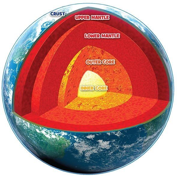
Inner Core
Temperature: 5,000°C – 6,000°C
State: Solid
Composition: iron and nickel
The Earth’s inner core is a huge metal ball, 2,500km wide. Made mainly of iron, the temperature of the ball is 5,000°C to 6,000°C – up to 6,000 times hotter than the atmosphere and hot enough to make metal melt. The metal at the inner core stays solid because of the incredible pressure surrounding it.
Outer Core
Temperature: 4,000°C – 6,000°C
State: Liquid
Composition: iron, nickel, sulphur and oxygen
This liquid layer of iron and nickel is 5,150km deep. The outer core flows around the centre of the Earth, and the movement of the metals creates our planets magnetic field.
Lower Mantle
Temperature: 3,000°C
State: solid
Composition: iron, oxygen, silicon, magnesium and aluminium
The lower mantle is found between 670km and 2,890km below the surface, and is made from solid rock. The rock is hot enough to melt but is solid because of the pressure pushing down on it.
Upper Mantle
Temperature: 1,400°C – 3,000°C
State: liquid / solid
Composition: iron, oxygen, silicon, magnesium and aluminium
This layer is up to 670km below the Earth’s surface. The lower part of the upper mantle is made from both solid and melted rock (liquid), while the rock in the upper region is stiffer because it’s cooler.
Crust
Temperature: Around 22°C
State: Solid
Composition: Oceanic crust made up of iron, oxygen, silicon, magnesium and aluminium.
Continental crust made up of granite, sedimentary rocks and metamorphic rocks.
The Earth’s surface is covered by its thinnest layer, the crust. Land is made of continental crust, which is 8km to 70km thick and made mostly of oceanic crust, which is about 8km thick and made mainly from a rock called basalt.

The spheres of the Earth
Everything in Earth’s system can be placed into one of four major subsystems: land, water, living things, or air. These four subsystems are called “spheres”. Specifically, they are the “lithosphere” (land), “hydrosphere” (water), “biosphere” (living things), and “atmosphere” (air). Each of these four spheres can be further divided into sub-spheres.
Lithosphere
The Lithosphere contains all of the cold, hard solid lands of the planet’s crust (surface, the semi-solid land underneath the crust, and the liquid land near the centre of the planet. The surface of the lithosphere is very uneven. There are high mountain ranges like the Rockies and Andes, huge plains or flat areas and deep valleys along the ocean floor.
The solid, semi-solid, and liquid land of the lithosphere form layers that are physically and chemically different. If someone were to cut through Earth to its centre, these layers would be revealed like the layers of an onion. The outermost layer of the lithosphere consists of loose soil rich in nutrients, oxygen, and silicon. Beneath that layer lies a very thin, solid crust of oxygen and silicon. Next is a thick, semi-solid mantle of oxygen, silicon, iron, and magnesium. Below that is a liquid outer core of nickel and iron. At the centre of the Earth is a solid inner core of nickel and iron.
Hydrosphere
The Hydrosphere contains all the solid, liquid, and gaseous water of the planet. It ranges from 10 to 20 kilometres in thickness. The hydrosphere extends from Earth’s surface downward several kilometres into the lithosphere and upward about 12 kilometres into the atmosphere. A small portion of the water in the hydrosphere is fresh. This water flows as precipitation from the atmosphere down to Earth’s surface, as rivers and streams along Earth’s surface, and as groundwater beneath Earth’s surface. most of Earth’s freshwater, however, is frozen.
Ninety-seven per cent of Earth’s water is salty. The salty water collects in deep valleys along Earth’s surface. These large collections of salty water are referred to as oceans. Water near the poles is very cold while the water near the equator is very warm. The differences in temperature cause water to change physical states. Extremely low temperatures like those found at the poles cause water to freeze into a solid such as a polar icecap, a glacier, or an iceberg. Extremely high temperatures like those found at the equator cause water to evaporate into a gas.
Biosphere
The Biosphere contains all the planet’s living things. This sphere includes all of the microorganisms, plants, and animals or Earth. Within the biosphere, living things form ecological communities based on the physical surroundings of an area. These communities are referred to as Biomes. Deserts, grasslands, and tropical rainforests are three of the many types of biomes that exist within the biosphere.
Atmosphere
The Atmosphere contains all the air in the Earth’s system. It extends from less than 1 m below the planet’s surface to more than 10,000 km above the planet’s surface. The upper portion of the atmosphere protects the organisms of the biosphere from the sun’s ultraviolet radiation. It also absorbs and emits heat. When air temperature in the lower portion of this sphere change, weather occurs. As the air in the lower atmosphere is heated or cooled, it moves around the planet. The result can be as simple as a breeze or as complex as a tornado.
Theory of Plate tectonics- evidence and mechanisms
The theory of plate tectonics states that the Earth’s solid outer crust, the lithosphere, is separated into plates that move over the asthenosphere, the molten upper portion of the mantle. Oceanic and continental plates come together, spread apart, and interact at boundaries all over the planet.
Plate boundaries
Divergent Boundaries
Each type of plate boundary generates distinct geologic processes and landforms. At divergent boundaries, plates separate, forming a narrow right valley. Here, geysers spurt super-heated water, and magma, or molten rock, rises from the mantle and solidifies into basalt, forming new crust. Thus, at divergent boundaries, oceanic crust is created. The mid-ocean ridge, the Earth’s longest mountain range, is a 65,000 kilometres long and 1,500 kilometres wide divergent boundary. In Iceland, one of the most geologically active locations on Earth, the divergence of the North American and Eurasian plates along the Mid-Atlantic Ridge can be observed as the ridge rises above sea level.
Convergent Boundaries
At convergent boundaries, plates collide with one another. The collision buckles the edge of one or both plates, creating a mountain range or subducting one of the plates under the other, creating a deep seafloor trench. At convergent boundaries, continental crust is created and oceanic crust is destroyed as it subducts, melts, and becomes magma. Convergent plate movement also creates earthquakes and often forms chains of volcanoes. The highest mountain range above sea level, the Himalayas, was formed 55 million years ago when the Eurasian and Indo-Australian continental plates converged. The Mediterranean island of Cyprus formed at a convergent boundary between the African and Eurasian plates. Hardened mounds of lava, called pillow lavas, were once on the bottom of the ocean where this convergence occurred, but have been pushed up and are now visible at the surface.
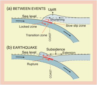
Subduction zones
Subduction zones are plate tectonic boundaries where two plates converge, and one plate is thrust beneath the other. This process results in geohazards, such as earthquakes and volcanoes.
Earthquakes- causes, distribution and monitoring
Cause
Earthquakes are among the most destructive natural phenomena on Earth. The shocks make the ground behave like the deck of a ship on a rough sea: it rises and falls in waves, sinks rapidly or even cracks. An earthquake is rarely longer than a few seconds, although some may even last for more than a minute.
And earth quake starts deep below the Earth’s surface. Tectonic plates moving past each other in opposite directions catch on each other’s edge irregularities, causing rock to become compressed and crushed.
The place below the Earth’s surface where a sudden dislocation of rocks occurs is called the focus of an earthquake or the hypocentre. On the other hand, the place on the surface directly above the surface is referred to as epicentre. The energy released is transferred through the crust and on the surface in the form of vibrations, referred to as seismic waves.
Types of Fault
Faults are fractures in Earth’s crust where rocks on either side of the crack have slid past each other.
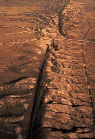
There are three kinds of faults: strike-slip, normal and thrust (reverse) faults. Each type is the outcome of different forces pushing or pulling on the crust, causing rocks to slide up, down or past each other.
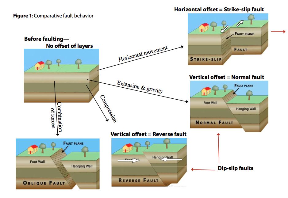
Strike-slip faults (tear fault) indicate rocks are sliding past each other horizontally, with little to no vertical movement.
Norma faults create space. Two block of crust pull apart, stretching the crust into a valley.
Reverse faults, also called thrust faults, slide one block of crust on top of another. These faults are commonly found in collision zones, where tectonic plates push up mountain ranges such as the Himalayas and the Rocky Mountains.
Measuring Earthquakes
Seismic waves are recorded by instruments called seismographs. The data recorded by seismographs can be used to determine the duration, epicentre, depth and intensity, or magnitude, or an earthquake.
Distribution
Earthquakes occur in seismic zones, which are regions characterised by frequent and powerful earthquakes, situated along mid-ocean ridges and oceanic trenches, along faults and in the neighbourhood of young mountains and volcanoes. It is impossible to say precisely when or where the next earthquake will occur.

The regions where two tectonic plates meet are characterised by frequent and powerful earthquakes.
Volcanoes – types, distribution and formation
Types of Volcanoes
Volcanoes occur in different shapes and sizes.
Shield Volcano
Shield volcanoes have gentle slopes and a wide base. The lava they expel is low-melting and flows easily.
Composite Volcanoes
Composite volcanoes have the characteristic shape of a cone with steep sides. They are made up of alternate layers of solidified lava and ashes.
Volcanic Dome
Volcanic domes form during outpourings of very thick lava, which hardens on the steep slopes.
Distribution
Most active volcanoes are situated on the boundaries of tectonic plates: along convergent boundaries and along divergent boundaries, or in regions affected by abnormally high heat flux from inside the Earth.


0 Comments